there was no Europe between 1945 and 1989
the cultural tourist as recipient
cartographic presentations in the internet
geographical specific data and Geographical Information Systems
isolated applications of cities and local authorities
The perennial central project of the European Centre for Culture and Information in Thuringia is the develoment of a VIA
REGIA-Geographical Informationsystem (GIS) about the European VIA REGIA-corridor.
Perspectively it establishes the information and communication base for different forms of regional and international
cooperation within the frame of VIA REGIA networks and moreover it includes a high (cultural) touristical serviceability.
The objective of a Geographical Information System VIA REGIA is a preferably diversified and detailed presentation of objects and
events within the VIA REGIA corridor in 10 European countries in future. The system should visualize the connection of the route
in a length of 4.500 km through Europe and at the same time should provide the exactness that is necessary for a real touristical
serviceability also for peripheral areas.
In this visualization we do not display only the historical route courses. We also use present forms of the VIA REGIA within the
European Development Corridor III e.g. the highway as well as hiking and biking trails. By mouse-click the user is able to fade
in and combine the drawn VIA REGIA courses in any order.
The following themes should be presented in the online platform:
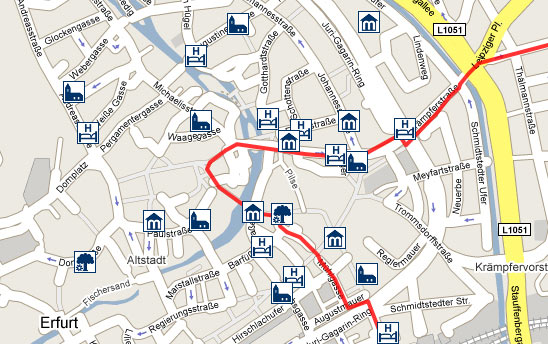
The user can fade in these objects along the chosen route courses. In doing so the respective institutions and events appear in
form of pictogrammes within the map. On pictogramme mouse-over the name of the object appears on mouse-click an additional
window including detailed information opens up. With that users can compose their individual tours - geographically and thematically.
Rural regions benefit from the equal presentation within the system next to popular destinations.
Thus we are able to communicate the historic dimension of the route and its present richness at the same time. The VIA REGIA
presented as European landscape of memory consisting of existing, remaining and emerging contents.


